| Home > All By Location regional map > Pittsburgh West > West End Bypass 2008 | |||
|
|
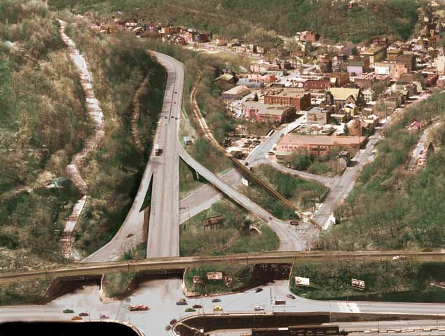
Retouched photo of proposed finished project (PennDOT) 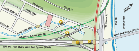
OFFICIAL NAME: OTHER DESIGNATION: West End Bypass Improvements: -- Norfolk Southern RR over West End Bypass (O) 2002 -- Steuben St Connector over Saw Mill Run (P) -- West End Bypass southbound ramp over South Main St (Q) -- West End Bypass over South Main St (R) LOCATION: Pittsburgh USGS 7.5" Topo Quad - UTM Coordinates: Pittsburgh West - Zone 17; 0582 4477 CARRIES: -- Steuben St Connector over Saw Mill Run -- West End Bypass southbound ramp over South Main St -- West End Bypass over South Main St BETWEEN: -- CROSSES: -- TYPE OF CONSTRUCTION / DESIGN: LENGTH OF MAIN SPAN: TOTAL LENGTH (including longest elevated ramp): HEIGHT OF DECK: YEAR ERECTED / ENGINEER: 2002-2008, PennDOT ADDITIONAL INFO: view page - Other structures in the West End Valley FIELD CHECKED: 10-May-2004 INFO SOURCES: field check; PennDOT website Submit info or inquiry - share some facts or ask a question. Introduction -- Nearby Structures Page created: Last modified: 13-Aug-2004 |
View Larger Map 
| |
| copyright: © Bruce S. Cridlebaugh 1999-2008 All Rights Reserved | |||