| Home > All By Location regional map > Braddock > Union Railroad [URR] over former Pennsylvania Railroad [PRR, NSRR] | ||||
|
|
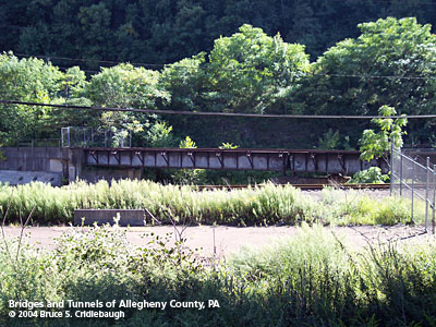
URR to PRR [NSRR] Port Perry Branch [bridge closed]
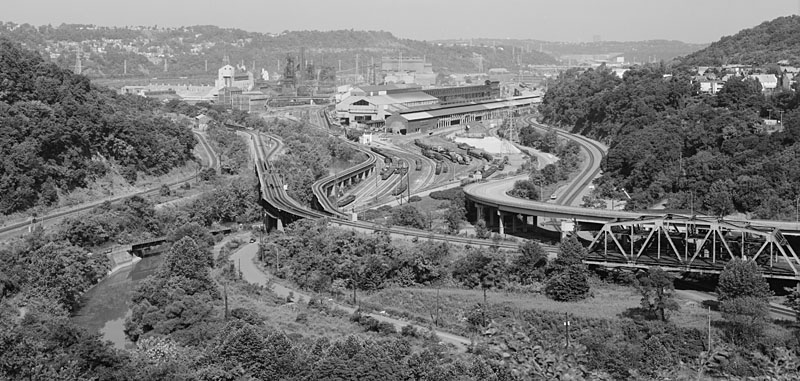
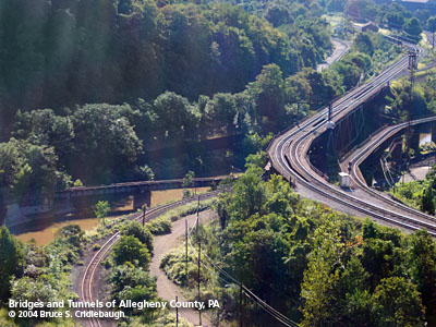
OTHER DESIGNATION: U Junction LOCATION: East Pittsburgh - North Versailles USGS 7.5" Topo Quad - UTM Coordinates: Braddock - Zone 17; 0598 4471 CARRIED: -- connection between URR and PRR BETWEEN: -- Union Railroad Port Perry Yard at Edgar Thomson Steel Works -- Pennsylvania Railroad Port Perry Branch CROSSES: -- Turtle Creek TYPE OF CONSTRUCTION / DESIGN: deck girder LENGTH OF MAIN SPAN: (north to south) 60 ft est [removed], 90 ft est, 100 ft est TOTAL LENGTH (including longest elevated ramp): 250 ft est HEIGHT OF DECK: YEAR ERECTED / ENGINEER: ADDITIONAL INFO: This was the townsite of Brinton, then Bessemer Junction, now part North Versailles and part East Pittsburgh. Where the Turtle Creek Valley opens to meet the Monongahela River had been mentioned in many historical documents related to George Washington, his rivalry with George Croghan, the cabin of trader John Fraser and others. The Turtle Creek Valley was prominent in its location on the Pennsylvania Railroad mainline between Pittsburgh and Philadelphia. The rail line had been completed from Pittsburgh to Turtle Creek in December 1851. A final section completed in November, 1852, opened the line to Philadelphia. The Edgar Thomson Works began operations in 1875, using the Bessemer process for the mass production of steel. The town of Brinton was plotted in 1890 and that same year, George Westinghouse began building numerous manufacturing complexes which ultimately stretched from East Pittsburgh as far upstream as Trafford. The ensuing industrial prosperity would overtake both Brinton and it neighbor to the south Port Perry. It was said the this area had the most dense rail traffic in the world. Over time, its location at the nexus of road and rail would obliterate all remants of the town: the Pennsylvania Railroad mainline and its branch to cross the Monongahela River at Port Perry (1877), the Bessemer & Lake Erie (1897, later the Union Railroad and its own crossing at Port Perry), the connection between the two at U Junction, the George Westinghouse Memorial Bridge (1930) and the expansion of the Port Perry yard at Edgar Thomson with the URR's High Grade and Low Grade Viaducts (1945). The last of the town's buildings were removed when Braddock Avenue was bypassed in this area with an elevated section of four-lane roadway in 1974. FIELD CHECKED: 21-Aug-2004 INFO SOURCES: field check; Hopkins map, 1903 Submit info or inquiry - share some facts or ask a question. Introduction -- Nearby Structures Page created: Last modified: 13-Apr-2009 |
View Larger Map 
| ||
| copyright: © Bruce S. Cridlebaugh 1999-2008 All Rights Reserved | ||||